New Jersey

Resilience System


You are here

Situation Reports - NJ

Primary tabs

This working group is focused on discussions about situation reports.

The mission of this working group is to focus on discussions about situation reports.

Members

Amanda Cole Kathy Gilbeaux mdmcdonald

Email address for group

situation-reports-nj@m.resiliencesystem.org

A Living, Lurking Threat in Sandy-Hit Homes: Mold

Submitted by Henry Rodriguez

Esther Tauscher stood outside her Staten Island home, leafing through boxes of family photos that had been steeped in storm water. She paused to point out life events — her honeymoon, holding her baby boy in a hospital bed.

The photos are just about all she has left. Behind her, the home where she and her family lived for 14 years was being dismantled by a masked volunteer crew that tossed out her possessions and ripped out floorboards and walls.

It was Tauscher’s only option. Her house and nearly everything in it was consumed by mold.

New FEMA Flood Maps Online

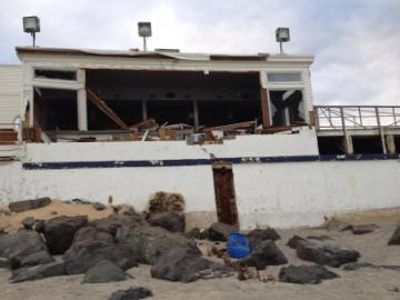
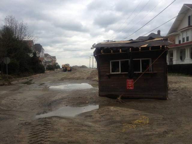
Asbury Park Press - by Kristi Funderburk - January 7, 2013
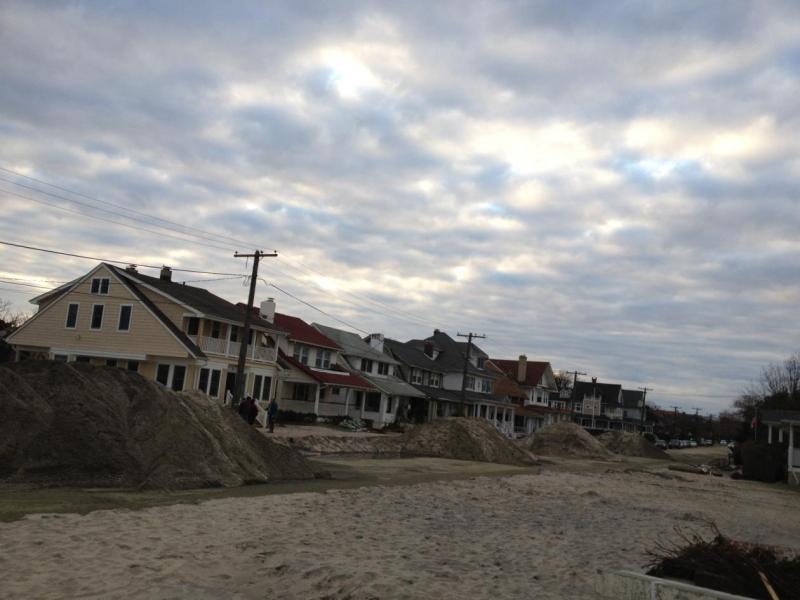
TRENTON — Residents looking to weigh their area’s flooding risks in the wake of superstorm Sandy can find answers online with the Federal Emergency Management Agency’s new advisory base flood elevation maps.

The advisory maps, available online for 10 New Jersey counties, including Ocean and Monmouth, show how high structures need to be raised to minimize damage from future flooding, agency spokesman Chris McKniff said in a news release.

The maps reveal parts of some communities are in new flood zones, a factor that could impact insurance rates and building practices, he said. To view flood elevations by address, visit www.region2coastal.com/sandy/table

(READ COMPLETE ARTICLE)

Hurricane Sandy Devastates my Hometown of Manasquan on the Jersey Shore

submitted by John Cocozza

I am sure that everyone has seen so much of the devastation from Hurricane Sandy as it slammed into cities like Atlantic City, Seaside Heights, Manhattan, and others.  Sometimes the images on TV might be larger than life but the media leaves us only a small view of the shear range of the devastation.   There were a couple hundred small towns and small communities along the coast from Ocean City, Maryland through the Jersey Shore and reach past Montauk, NY out on Long Island.  These small towns I can tell you from first hand knowledge are our Main Street, USA's.


See the attached document for the full text.

Situation Reports - Jersey Shore

Submitted by Jeff Williams

Everything is unavailable. No food stores open cause no power. No gas stations cause no power. Generators running emergency red cross shelters.  But people are moving back into homes without power just to start cleaning up and getting assessments for repair needs.  

Bulldozers coming to plow 4 ft of sand in streets.  More than 300 telephone pole mounted transformers are broken and need to be repaired just for power distribution to northern monmouth county.  Numerous telephone poles are down of leaning at 45 degree angles and have to be replaced.  Manpower for such repairs is unavailable. And how to allocate such resources and prioritize repair locations. 

Situation Report - Loch Arbor, NJ

Starting to remove 4 ft of ocean sand from streets so emergency vehicles and access disaster area.

Starting to remove 4 ft of ocean sand from streets so emergency vehicles can access the disaster area.  

Situation Report - Loch Arbour, NJ

Mr. C's Beach Bistro

submitted by Jeff Williams - November 4, 2012

Hi all. I'm at jersey shore now in ground zero. Our house has 4 ft of sand and 6 ft of sea water on top of that. Most of neighbors homes are destroyed as waves broke through second floor windows and exited by breaking out through first floor walls and doors. Dead fish throughout. FEMA and other recovery organizations and can't get their equipment through the heavy compacted 4 ft of wet sand to start draining homes and checking has lines. Neighbor's red couch was found 3/4 mile inland.

I am in the evacuation zone without power for miles. Sleeping in cold house night temps are in high 30s. Stunned silence as residents return and wander along beach and neighborhoods. But ocean is strikingly beautiful today with glassy sunrise, off shore breeze and 3 ft barrels coming off the sandbars.

Pics to follow. But it will be long time to just dig out. And destroyed homes stores and schools have no prospect of quick recovery. Will take herculean policy and political decisions to figure out how to assist recovery, and insurance companies are already denying coverage for losses.

Jeff

Loch Arbour Takes a Pounding from Sandy

submitted by Jeff Williams


11/1/12 Beach club's ticket booth sits a block from beach in middle of ocean avenue. Staff Photo Nancy Shields

app.com - by Nancy Shields - November 2, 2012

LOCH ARBOUR — This seaside village’s homes got their share of battering, and the tiny municipal beach club was wiped out by Hurricane Sandy. The ticket stand from the beach was sitting a block inland on Ocean Avenue on Thursday.

Workers from neighboring Allenhurst were removing three to four feet of sand and debris from the now closed-off streets that run perpendicular to the beach Thursday.

(READ COMPLETE ARTICLE)

Hazardous Weather Outlook - Wind and Flood Warnings

THIS HAZARDOUS WEATHER OUTLOOK IS FOR NORTHEAST NEW JERSEY 
AND SOUTHEAST NEW YORK.
...WIND ADVISORY IN EFFECT UNTIL 6 AM EST THURSDAY...
...COASTAL FLOOD WARNING REMAINS IN EFFECT UNTIL 8 AM EST
THURSDAY...
(CLICK HERE FOR DETAILS FROM NATIONAL WEATHER SERVICE)

(WATCHES, WARNINGS, AND ADVISORIES)
howdy folks